


Zoning Rules in Action Through Dubai Architectural Models
Dubai’s architectural development is driven by a complex system of zoning regulations. These laws influence every phase of construction, including architectural model making. In Dubai, scale models are more than just visual tools.
They are detailed representations shaped by planning rules, urban guidelines, and legal compliance. When developers, architects, or government bodies request a model, zoning compliance is one of the key expectations. Let’s explore how these laws are reflected in architectural model making across Dubai.
Understanding Zoning in Dubai
Zoning in Dubai refers to the legal division of land for different purposes. Each zone is assigned a category such as residential, commercial, mixed-use, or industrial. These zones come with rules regarding building heights, setbacks, floor area ratios, land coverage, and use types.
The Dubai Municipality, along with entities like the Dubai Land Department and Trakhees, enforces these zoning regulations. Compliance is mandatory for both small projects and mega-developments. This makes it essential for architectural model makers to integrate zoning data into their designs.
Model Makers Start with Zoning Maps
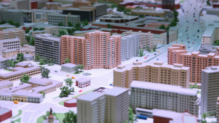
The process of integrating zoning laws begins at the planning stage. Model making firms in Dubai start by referencing official zoning maps. These maps show plot boundaries, land use permissions, height limits, and green space allocations.
Model makers collaborate with architects and planners to understand the regulatory framework. This ensures that each structure shown in the model aligns with legal constraints. For example, if a plot is marked for low-rise villas, the model must not depict high-rise towers on it.
Height and Density Limits in Models
Zoning laws in Dubai place specific limits on building height and density. These restrictions are directly reflected in architectural scale models. A tower shown in the model must not exceed the maximum height allowed for that plot.
Likewise, density limits such as the Floor Area Ratio (FAR) are carefully respected. FAR defines how much total floor space can be built on a plot. If the law permits a FAR of 3.0, the total built-up area in the model must not exceed three times the land area.
This ensures that models are realistic and regulation-compliant. It also helps clients, city officials, and investors visualize the project within legal bounds.
Open Space and Setback Representation
Dubai’s zoning codes often require setbacks from property lines. They also mandate the provision of green spaces, sidewalks, and access routes. These elements are all included in architectural model making Dubai.
Model makers allocate visible space between buildings and plot borders to reflect setbacks. Parks, communal areas, water features, and landscaped zones are also represented where zoning laws require them.
These features are not just decorative in the model. They are visual indicators of legal compliance and help demonstrate that the design respects public space regulations.
Mixed-Use Zoning Integration
Some areas in Dubai are designated as mixed-use zones. These allow a combination of residential, retail, hospitality, or office functions. Model makers must accurately reflect this mixed-use character in their models.
For example, a podium may feature retail outlets, while towers above could be residential or commercial. The use mix is represented through clear differentiation in the scale model. Color codes, signage, and lighting may also be used to indicate varied functions while staying within zoning requirements.
Parking, Access, and Transport Links
Zoning in Dubai also includes requirements for vehicle access and parking provisions. Developers must meet minimum parking standards depending on building use.
Architectural models often include basement or podium parking layouts. Vehicle access points, drop-offs, and connection to nearby roads are shown in detail. These elements are designed in coordination with traffic and access guidelines from Dubai’s Roads and Transport Authority (RTA).
In transit-oriented zones, model makers might include nearby metro stations or public bus lines. This helps present a full picture of zoning and mobility compliance.
Fire Safety and Building Separation
Zoning rules also deal with safety, especially fire separation distances between buildings. These rules influence how buildings are placed on plots within the model.
Model makers must ensure that the spacing between buildings reflects minimum distance requirements. In high-density districts, this spacing becomes critical. Fire lanes, emergency access points, and safety buffers are often included to satisfy code and enhance realism.
Master Planning and Government Review
Large masterplans in Dubai are subject to thorough zoning reviews. Government stakeholders often use scale models to assess compliance before approving final plans.
These architectural models help visualize how zoning laws have been applied across districts. Model makers must follow the official land use breakdowns and ensure accurate scaling of all plot uses.
Failure to comply with zoning in the model can result in delays or rejections. Hence, zoning integration is a technical and legal requirement for model approval in many major developments.
Conclusion
Zoning laws in Dubai are not just paperwork—they shape the skyline. Architectural model making is one of the first steps where these rules come to life. From building heights and land use to green space and traffic access, every element in a model reflects zoning compliance.
Dubai’s model making studios combine creativity with legal precision. They use zoning data to ensure accuracy, compliance, and clarity. This enables developers to communicate effectively with clients, regulators, and the public. It also ensures that what is seen in the model is legally possible in reality.
In Dubai’s fast-moving real estate market, a regulation-friendly model is more than a visual—it’s a strategic tool for approvals and success.